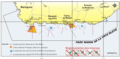
Côte Bleue marine park
Côte Bleue marine park
- Country : FRANCE
- Year of creation : 2004
- Year of inclusion : 2012
- Status : Marine park
- Creation text : Decree of 16 December 2004 renewing the fishing reserves in the department of Bouches-du-Rhône in front of the municipalities of Carry-le-Rouet and Martigues 2004, grouped in association «Parc Marin de la Côte Bleue». Decree of 01/07/14 renewing the fishing districts in the municipalities of Carry-le-Rouet and Martigues (Bouches-du-Rhône)
- Area : 18,928.00 ha
- Marine area : 18,900.00 ha
- Main rib length : 25.00 km
- Category : SPAMI
Website : www.parcmarincotebleue.fr
Download the sheet